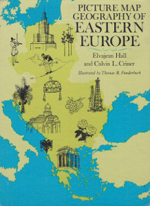
Picture Map Geography of Eastern Europe
Calvin L. Criner, Elvajean Hall
Author:
Calvin L. Criner, Elvajean Hall
Illustrator:
Thomas R. Funderburk
Publication:
1968 by J.B. Lippincott Company
Genre:
Geography, Non-fiction
Series:
Picture Map Geography ![]() Members Only
Members Only
Pages:
155
Current state:
Basic information has been added for this book.
It is under consideration and will be updated when it is evaluated further.
Book Guide
Search for this book used on:
Long ago nomadic peoples from Asia Minor pushed westward across the Bosphorus in search of better food for their flocks. Later on power-hungry rulers sent their armies across this waterway to plunder the rich European valleys. Thus Eastern Europe today contains a surprising blend of European and Asian cultures.
These countries—Czechoslovakia, Poland, Hungary, Rumania, Bulgaria, Yugoslavia, Albania, and Greece—have had constantly changing outlines on the map. Sometimes they have bulged and narrowed in surprising ways, for in the nineteenth and early twentieth centuries the national boundaries of many small countries were drawn up by foreign diplomats—often working for their own ends. Sometimes people who have been united for hundreds of years by the same religion and culture would suddenly find themselves separated and placed in two or three different nations.
The complexity of Eastern Europe is described and clarified in this book. Emphasis has been placed on the history, culture, geographic features, and products of each country. The illustrations and handsome maps are the work of Thomas R. Funderburk.
From the dust jacket
To view an example page please sign in.

Calvin L. Criner
Calvin L. Criner, formerly head of the history department of Lees-McRae College, has helped Miss Hall greatly in her research for this book. From t... See moreElvajean Hall
1908 - 1984American
Elvajean Hall was born in Illinois and attended Chicago suburban schools. She holds a Bachelor of Arts degree from Oberlin College and a Master of S... See more
Thomas R. Funderburk
1928 -American
Thomas R. Funderburk was born and grew up in Indiana. He spent two years in the Marine Corps and later graduated from Indiana University. He enjoys ... See more
Find This Book
Search for this book used on: